


Fairly widespread to widespread rainfall activity with isolated heavy falls very likely to continue over East Uttar Pradesh, Bihar, West Bengal & Sikkim and northeastern states during next 5 days
Rainfall very likely over central & adjoining east India during next 3 days and increase in intensity & distribution thereafter
Widespread rainfall activity very likely to continue along the west coast during next 5 days. Isolated heavy to very heavy falls is also very likely over Konkan & Goa during next 5 days
Subdued rainfall activity over Western Himalayan Region and adjoining northwest India very likely to continue during next 3 days
Posted On: 30 JUN 2020 8:52PM by PIB Delhi
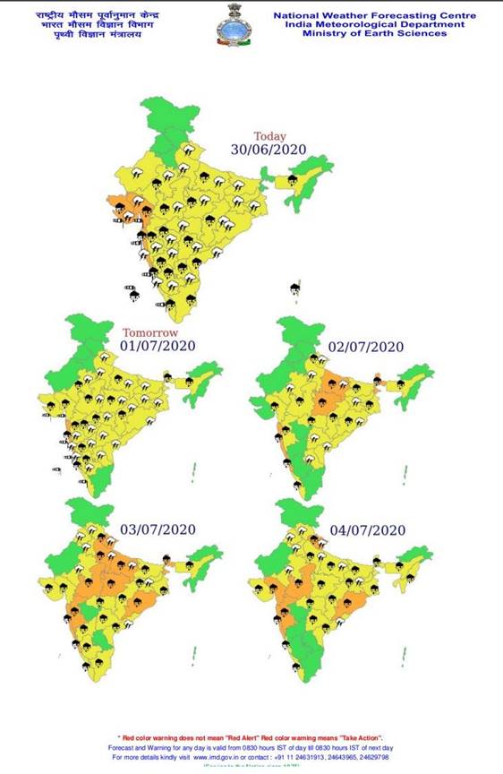
The National Weather Forecasting Centre/Regional Meteorological Centre, New Delhi of the India Meteorological Department (IMD) has said:
♦ The Western end of the monsoon trough at mean sea level is near its normal position and eastern end is north of its normal position and extends upto 1.5 km above mean sea level. A cyclonic circulation lies over North Chhattisgarh & neighbourhood between 3.1 km & 4.5 km above mean sea level.
♦ Under its influence, fairly widespread to widespread rainfall activity with isolated heavy falls very likely to continue over East Uttar Pradesh, Bihar, West Bengal & Sikkim and northeastern states during next 5 days. Isolated heavy to very heavy falls is also likely over East Uttar Pradesh and Sub-Himalayan West Bengal & Sikkim on 2nd & 3rd July, 2020.
♦ Scattered to fairly widespread rainfall very likely over central & adjoining east India during next 3 days and increase in intensity & distribution thereafter. Isolated heavy falls also very likely over Madhya Pradesh during next 3 days and isolated heavy to very heavy falls thereafter; isolated heavy falls over Chhattisgarh during next 5 days; over Bihar & Vidarbha from 1st to 4th July and heavy to very heavy at isolated places over Odisha from 2nd to 4th July, 2020.
♦ Widespread rainfall activity very likely to continue along the west coast during next 5 days. Isolated heavy to very heavy falls is also very likely over Konkan & Goa during next 5 days; Isolated heavy falls very likely over Coastal Karnataka during next 3 days and isolated heavy to very heavy falls thereafter and heavy falls over Kerala during next 5 days.
♦ Subdued rainfall activity over Western Himalayan Region and adjoining northwest India very likely to continue during next 3 days and its distribution & intensity very likely to increase thereafter.
Weather warning for the next 5 days:
Kindly visit www.imd.gov.in for updates.


