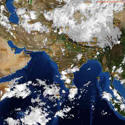
Realised Weather during past 24 hrs ending of 0830 IST of Today (14 May 2018)
-
- Rain/thundershowers accompanied with gusty / squally wind occurred at most places over Uttarakhand, East Uttar Pradesh, Bihar, Jharkhand, West Bengal & Sikkim and Nagaland, Manipur, Mizoram & Tripura; at many places over Himachal Pradesh, Coastal & South Interior Karnataka, Chhattisgarh and Kerala; at a few places Jammu & Kashmir, West Uttar Pradesh, Haryana, Chandigarh & Delhi, East Madhya Pradesh, Odisha, North Interior Karnataka and Rayalaseema and at isolated places over Punjab, West Madhya Pradesh, Telangana, Coastal Andhra Pradesh, Assam & Meghalaya, Madhya Maharashtra, Lakshadweep and Andaman & Nicobar Islands.
Following maximum wind has been recorded during past 24 hours:
Station Wind speed (Kmph) Time
| Delhi (Safdarjung) | 107 | 1644-1646 hrs |
| Delhi (Palam) | 96 | 1633-1634 hrs |
- Current Weather systems and its forecast
-
- The Western Disturbance as a trough lies over Pakistan & adjoining Afghanistan in middle tropospheric levels. It is likely to move eastwards during next 48 hours.
- A cyclonic circulation lies over central Pakistan and adjoining northwest Rajasthan and Punjab in lower levels. It is likely to weaken after 24 hours.
- The north-south trough runs from the above cyclonic circulation to north Madhya Maharashtra across southeast Rajasthan and West Madhya Pradesh at lower levels. It is likely to weaken gradually during next 48 hours.
- A cyclonic circulation lies over northern parts of West Bengal & neighbourhood in lower levels. It is likely to persist over the same region during next 24 hours and weaken thereafter gradually.
- The north-south trough runs along Long. 88°E to the north of 24°N at 3.1 km above mean sea level. It is likely to move eastwards gradually.
- There is a north-south wind discontinuity from Rayalaseema to south Tamilnadu in lower levels.
- Weather Forecast
- Rain/thundershowers very likely at most places over Jammu & Kashmir, Himachal Pradesh, Uttarakhand, West Bengal & Sikkim; at many places over Assam & Meghalaya, Nagaland, Manipur, Mizoram & Tripura, Kerala, South Interior Karnataka and at isolated to a few places over rest of the country outside Rajasthan, Gujarat, north Konkan and north Madhya Maharashtra where weather likely to be dry during next 2-3 days.
- Weather warnings for next 2 days (14-15 May 2018):
-
- Thunderstorm accompanied with squall and hail (wind speed reaching 50-70 kmph) very likely at isolated places over Jammu & Kashmir, Himachal Pradesh and Uttarakhand and squall at isolated places over Gangetic West Bengal and Odisha.
- Thunderstorm accompanied with gusty winds (wind speed reaching 50-60 kmph) very likely at isolated places over Punjab, Haryana, Chandigarh & Delhi, Uttar Pradesh, Jharkhand, Assam & Meghalaya, Nagaland, Manipur, Mizoram & Tripura and wind speed reaching 40-50 kmph over Coastal Andhra Pradesh, Rayalaseema, South Interior Karnataka, Tamilnadu & Puducherry.
- Heavy rain very likely at isolated places over Sub-Himalayan West Bengal & Sikkim, Kerala, South Interior Karnataka, interior Tamilnadu and Assam & Meghalaya.
- Duststorm very likely at isolated places over Rajasthan.
The verification of thunderstorm warning issued on 13th May 2018 based on the realized weather during past 24 hours ending at 0830 hrs. IST of 14th May is given in the enclosed table.
| S.No. | Sub-Division | Forecast
warnings |
Realized weather (highest rain in cm)
recorded at 0830 hrs of 14 May 2018 |
| 1 | ANDAMAN & NICO. ISLANDS | ||
| 2 | ARUNACHAL PRADESH | ||
| 3 | ASSAM & MEGHALAYA | TS+ GW | TS+ GW |
| 4 | NAGA.MANI.MIZO.& TRIPURA | TS+ GW | TS+GW (Kohima & Kailashahar-1) |
| 5 | SUB-HIM.W. BENG. & SIKKIM | ||
| 6 | GANGETIC WEST BENGAL | TS+ GW | TS+GW (Canning-6) |
| 7 | ODISHA | TS + Squall | TS+GW (Chandbali-6) |
| 8 | JHARKHAND | TS+ GW | TS+GW (Daltonganj-2) |
| 9 | BIHAR | ||
| 10 | EAST UTTAR PRADESH | TS+ GW | TS+Squall (Gorakhpur-3) |
| 11 | WEST UTTAR PRADESH | TS+ GW | TS+Squall (Bareilly-2) |
| 12 | UTTARAKHAND | TS + Squall | TS+Squall |
| 13 | HARYANA CHD. & DELHI | TS+ GW | TS + GW+Squall (Ambala-2) |
| 14 | PUNJAB | TS+ GW | TS+GW (Patiala-1) |
| 15 | HIMACHAL PRADESH | TS + Squall | TS+GW (Solan-3) |
| 16 | JAMMU & KASHMIR | TS+ GW | TS+GW |
| 17 | WEST RAJASTHAN | DS | DS |
| 18 | EAST RAJASTHAN | DS | DS |
| 19 | WEST MADHYA PRADESH | TS+ GW | TS+GW |
| 20 | EAST MADHYA PRADESH | TS+ GW | TS+GW |
| 21 | GUJARAT REGION D.D. &
N.H. |
||
| 22 | SAURASTRA KUTCH & DIU | ||
| 23 | KONKAN & GOA | ||
| 24 | MADHYA MAHARASHTRA | ||
| 25 | MARATHAWADA | ||
| 26 | VIDARBHA | TS+ GW | |
| 27 | CHHATTISGARH | TS+ GW | TS+GW |
| 28 | COASTAL ANDHRA
PRADESH |
TS+ GW | TS+GW |
| 29 | TELANGANA | TS+ GW | TS |
| 30 | RAYALASEEMA | TS+ GW | TS+GW |
| 31 | TAMILNADU & PUDUCHERRY | TS+ GW+HR | TS+GW (Kakinada-3) |
| 32 | COASTAL KARNATAKA | TS+GW (Mangalore-5) | |
| 33 | NORTH INT.KARNATAKA | TS+GW (Belgaum-5) | |
| 34 | SOUTH INT.KARNATAKA | TS+ GW | TS+GW |
| 35 | KERALA | TS+ GW+HR | TS+GW (Thiruvananathapuram-6) |
| 36 | LAKSHADWEEP |
Legends: TS=Thunderstorm; GW=Gusty winds and HR= Heavy Rain


