


Scientists decode the reason behind the Chamoli disaster
By PIB Delhi
Little more than a year after the deadly ice-rock mass avalanche in Chamoli district in the Uttarakhand state that led to a significant causality of more than 200 people and a substantial economic loss, scientists have been able to decode the reason behind the disaster.
Scientists have found that the region was seismically active before the disaster hit. They also found a noteworthy sequence of precursory signals of rock-ice detachment preceded by a formation of a new structure via self-assembly or self-organization called the dynamic nucleation phase.
Retreating Himalayan glaciers and associated melt along with unstable slopes are subject to trigger landslides by rainfall during monsoon or by induced seismicity in the region. Also, the snow, ice and rock avalanches may threaten people and infrastructure downstream in mountainous areas worldwide. This is why the area requires constant monitoring of seismicity as well as glacier status.
Wadia Institute of Himalayan Geology (WIHG), since its inception, has been actively involved in understanding the processes responsible for such disasters and focusing on detecting significant and unfelt activities with a dense network of seismic stations in the vicinity of Himalayan glaciers. As a part of this process, they have also tried to trace the reasons behind the disaster that took place on February 7, 2021,
The group of 9 scientists analyzed the satellite images of the avalanche zone and found that it shows gradual growth of cracks and the joint near the crown of the weak wedge that has controlled the head scarp for the last 5 years. These cracks further started to open up and led to successive advancement of a weak zone near the crown of the wedge failure. The initiation of the ice-rock mass avalanche has been recorded as seismic precursors, which were continuously active for 2.30 Hr before the main detachment took place. Scientists analyzed and verified the seismic signals with field evidence to evaluate the velocity of dynamic flows and associated impacts. Such high-quality seismic data allowed to reconstruct the complete chronological sequence and evaluate effects from the initiation to the advancement of debris flow. The study has been published in the journal Scientific Reports.
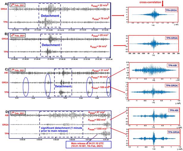
Figure: Waveform cross-correlation between different stations denoting the nucleation phase (weak zone advancement and pre-detachments) had started a day before avalanche release and correlated perfectly. It is seen that all the impacts are first recorded in the (Tapovan) TPN observatory, which is near the source. Waveform cross-correlations (A–D) are depicted for the blue dotted rectangle. (C) The blue elliptical circle shows the weak/small detachment recorded in two nearby observatories. (D) Significant detachment or weak zone advancement (T0) just 1 min prior to the main release/detachment (T1) can be seen in three nearby seismic stations with perfect cross-correlation of the seismic waveform.
Apart from the human loss, the impact of the flash flood was too high to sustain the modern structures i.e., two hydropower projects, bridges, and roads. The high-flow intensity of the flood disturbed the stability of the Raini village, and thus the area is prone to landslides, especially during the monsoon.
Seismic monitoring systems are well suited to detect mass movements such as debris flow, landslides, avalanches, etc. The ability to see such activities by a seismic network before the main failure could provide a scope for developing an early warning system for the region. An integrated early warning system can alert the people towards the mitigation of any such impending disaster. The EWS should be based on seismic data from the seismometers, hydrological data from automatic water level recorders, and meteorological data from automatic weather stations installed as a network in the vicinity of a glaciers basin of the Himalayas.


